 |
|
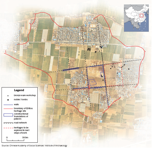
An illustrated map of Erlitou shows the city was divided into separate grids by crisscrossing road networks. [Photo provided to China Daily] |
Early state
The Erlitou site has ignited fierce academic debate since it was discovered in 1959.
In recent years, a mainstream theory in China has led archaeologists to believe the site to be Zhenxun, the last recorded Xia capital city, mainly because of analyses of its unearthed objects, documents from later periods and comparative studies with other ruins near Erlitou. The most recent carbon dating shows this city existed from about 1750 BC to 1520 BC, which accords with ancient records.
However, the lasting dispute about which dynasty it belongs to seems to have distracted experts from digging deeper to uncover the city's significance.
Du Jinpeng, a researcher with the Institute of Archaeology who led the excavations in Erlitou in the 1990s, says the first 40 years of studies of the site only provided some scattered "puzzles" and lacked the clues needed for a major breakthrough.
"But the last 20 years of efforts focusing on the city's layout have helped us to gain a general understanding of its structure," Du says. "The new finding is exciting because the city was well planned and more advanced than Yinxu from a later period."
The centuries-younger Yinxu Ruins in Anyang, Henan province, are the remains of the Shang Dynasty's (c. 16th century-11th century BC) capital and home to oracle-bone inscriptions-the earliest written Chinese characters discovered.
As to the multigrid layout in ancient Chinese capital cities, experts believe the most famous example may be the metropolis of Chang'an (today's Xi'an in Shaanxi province), which was the capital of the Tang Dynasty (618-907). Its layout is like a huge chessboard composed of walled-in residential communities and business districts. This format was also borrowed by ancient capital cities in Japan.